


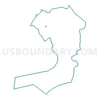
Voting District 3000071, Queens County, New York
About
Outline

Summary
| Unique Area Identifier | 634842 |
| Name | Voting District 3000071 |
| County | Queens County |
| State | New York |
| Area (square miles) | 0.02 |
| Land Area (square miles) | 0.02 |
| Water Area (square miles) | 0.00 |
| % of Land Area | 100.00 |
| % of Water Area | 0.00 |
| Latitude of the Internal Point | 40.73536070 |
| Longtitude of the Internal Point | -73.88971790 |
Maps

Graphs
Select a template below for downloading or customizing gragh for Voting District 3000071, Queens County, New York


Neighbors
Neighoring Voting District (by Name) Neighboring Voting District on the Map
- Voting District 3000072, Queens County, NY
- Voting District 3000082, Queens County, NY
- Voting District 3000083, Queens County, NY
- Voting District 3000084, Queens County, NY
- Voting District 3400051, Queens County, NY
- Voting District 3400070, Queens County, NY
- Voting District 3500089, Queens County, NY
Top 10 Neighboring County Subdivision (by Population) Neighboring County Subdivision on the Map
Top 10 Neighboring Place (by Population) Neighboring Place on the Map
Top 10 Neighboring Unified School District (by Population) Neighboring Unified School District on the Map
Top 10 Neighboring State Legislative District Lower Chamber (by Population) Neighboring State Legislative District Lower Chamber on the Map
- Assembly District 35, NY (130,758)
- Assembly District 30, NY (122,060)
- Assembly District 34, NY (121,976)
Top 10 Neighboring State Legislative District Upper Chamber (by Population) Neighboring State Legislative District Upper Chamber on the Map
Top 10 Neighboring 111th Congressional District (by Population) Neighboring 111th Congressional District on the Map
Top 10 Neighboring Census Tract (by Population) Neighboring Census Tract on the Map
- Census Tract 479, Queens County, NY (5,456)
- Census Tract 499, Queens County, NY (5,071)
- Census Tract 497, Queens County, NY (3,021)
- Census Tract 489, Queens County, NY (1,486)